Calaveras County, California
Nestled in the Sierra Nevada foothills, Calaveras County is known for its Gold Rush history, giant sequoias, and Mark Twain's celebrated jumping frog. But starting in 2016, it became the center of a different kind of story.
When California legalized recreational cannabis with Proposition 64, Calaveras County introduced an Urgency Ordinance to regulate and tax cultivation — setting off a land rush that would transform the county's landscape.
2015 Butte Fire: Creates the Opportunity
In September 2015, the Butte Fire tore through Amador and Calaveras counties, destroying 965 structures across 70,868 acres and killing two people (CAL FIRE, 2015). It was one of the most destructive fires in California history at the time — and it set off a real estate collapse that would reshape who owned the land.
Calaveras County Assessor Leslie Davis surveyed 2,579 fire-impacted parcels — 5.5% of all parcels in the county — and documented roughly $47 million in lost assessed property value (Calaveras Enterprise, 2016). Burned parcels — many with destroyed structures, no utilities, and no immediate path to rebuilding — sat on the market at steep discounts. Longtime residents who lost their homes often sold rather than rebuild, and insurers' payouts frequently didn't cover replacement costs. The result was a wave of distressed parcels entering the market at prices well below pre-fire values.
Within months, buyers began acquiring these cheap, disturbed rural parcels — including out-of-county investors and operators who had no prior connection to the area. The fire had cleared the land, removed many existing owners, and opened access roads. When Calaveras County introduced its 2016 Urgency Ordinance — requiring applicants to already be actively cultivating — those who had moved quickly to acquire and disturb burned parcels were in position to qualify. The fire didn't just create a landscape opportunity; it created a financial one.
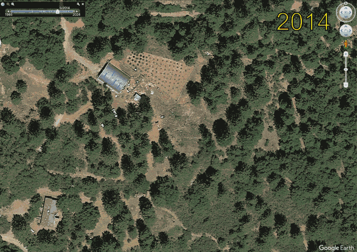
Use the slider to compare 2014 (left) and 2016 (right). The visible clearing, access roads, and disturbed earth in 2016 is the physical record of that transition.
🟧 Orange fill shows the 2015 Butte Fire perimeter (~70,846 GIS acres), about 11% of Calaveras County's total area (~1,037 square miles). 🟦 Blue outlines show the 712 parcels that applied for cultivation permits under Calaveras County's 2016 Urgency Ordinance.
The Boom: 2016
By 2016, the impact is unmistakable. NAIP imagery reveals widespread clearing within cannabis-permitted parcels — bare earth, access roads, hoop houses, and cultivation rows.
The county's Urgency Ordinance required applicants to already be growing cannabis before applying, which incentivized rapid clearing of forested land to establish operations before the permit deadline.
At the peak, the county cannabis registry captured 1,015 records; some entries did not include parcel numbers because they were protected medical cannabis permits.
After the Ban: 2018
In 2018, the Board of Supervisors banned all commercial cannabis cultivation, making previously permitted sites illegal. The 2018 NAIP imagery tells a mixed story:
- Some sites show signs of abandonment — regrowth beginning to reclaim cleared areas
- Other sites show continued or expanded clearing, suggesting illegal cultivation persisted
- The environmental damage — deforestation, soil disturbance, altered drainage — remained visible
Today, even where some of these scars are partially hidden by new vegetation, the underlying disturbance remains.
By 2022, only 65 licensed cultivation sites remained, while unpermitted activity continued at a wider scale, as documented in the 2023 Calaveras County Civil Grand Jury Report.
Mapping the Invisible
This map was built using data that was never meant to be a map. Through a California Public Records Act request, we obtained the Calaveras County Planning Department's cannabis permit registry under the 2016 Urgency Ordinance, including records with public parcel numbers.
We extracted 712 parcel numbers from the PDF using text processing, then joined them against the county's GIS parcel boundaries to create a spatial dataset of cannabis cultivation sites.
🔴 Red polygons show 2016 detected cannabis farms, identified via ML semantic segmentation of NAIP imagery.
Teaching Machines to See Cannabis Farms
We trained a semantic segmentation model (U-Net with ResNet-50 backbone) on manually annotated 2016 NAIP imagery to detect cannabis cultivation sites from aerial imagery.
The red polygons on the map are 2016 detected cannabis farms. The model identifies characteristic patterns: cleared forest patches, organized rows, hoop house structures, and access roads within the parcels.
Current limitations include false positives on vineyards and orchards. Multi-temporal training across 2014, 2016, and 2018 is a next step.
Environmental Impact
According to the 2023 Calaveras County Civil Grand Jury Report, illegal cannabis cultivation has significantly impacted the environment:
- Deforestation of native oak woodland and mixed conifer forest
- Soil contamination from pesticides and fertilizers
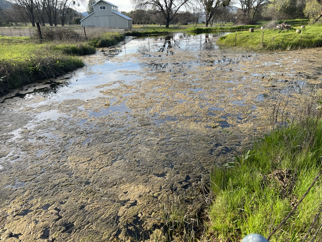
- Water contamination and overuse of groundwater
- Habitat fragmentation affecting wildlife corridors
Environmental damage often went unaddressed due to limited coordination among county agencies, insufficient resources, and weak penalties.
How This Was Made
Data sources:
- NAIP aerial imagery (2014, 2016, 2018) via USDA/Microsoft Planetary Computer
- Cannabis permit records via California Public Records Act
- County parcel GIS data (2022)
- 2023 Civil Grand Jury Report
Tools: Python, GDAL, Leaflet.js, TorchGeo, LabelMe
Looking Forward
Calaveras County's cannabis story is a cautionary tale about the unintended consequences of rapid legalization without adequate environmental safeguards.
Aerial imagery provides a powerful, objective record of land use change that persists long after political debates have moved on. By combining public records with remote sensing, we can quantify environmental impacts that might otherwise go unmeasured.
This project is ongoing. We plan to extend the analysis to additional years and neighboring counties.
Discussion
Comments are powered by utteranc.es and stored as GitHub Issues. A GitHub account is required to comment.